Historical Imagery Timeline
The historical imagery mode, its timeline panel, the Catalogs picker, a tick's card and the dedicated entry point
Historical Imagery mode
"Historical Imagery" is a single combined basemap entry. Behind it are the timeline's own providers (ESRI Wayback, Google Earth Historical, Bing, Planet, NASA HLS, EOX Sentinel-2) and, through the Catalogs picker, a few hundred dated archives: post-crisis open data, the OSM Editor Layer Index, about seventy national and regional mapping agencies, and digitised old maps. Each of them, with its years and its link, is listed on Historical Sources, along with the services that could not be added and why.
Which source renders for a given view and date is chosen on the timeline panel at the bottom of the map, not in the sidebar.
The timeline panel
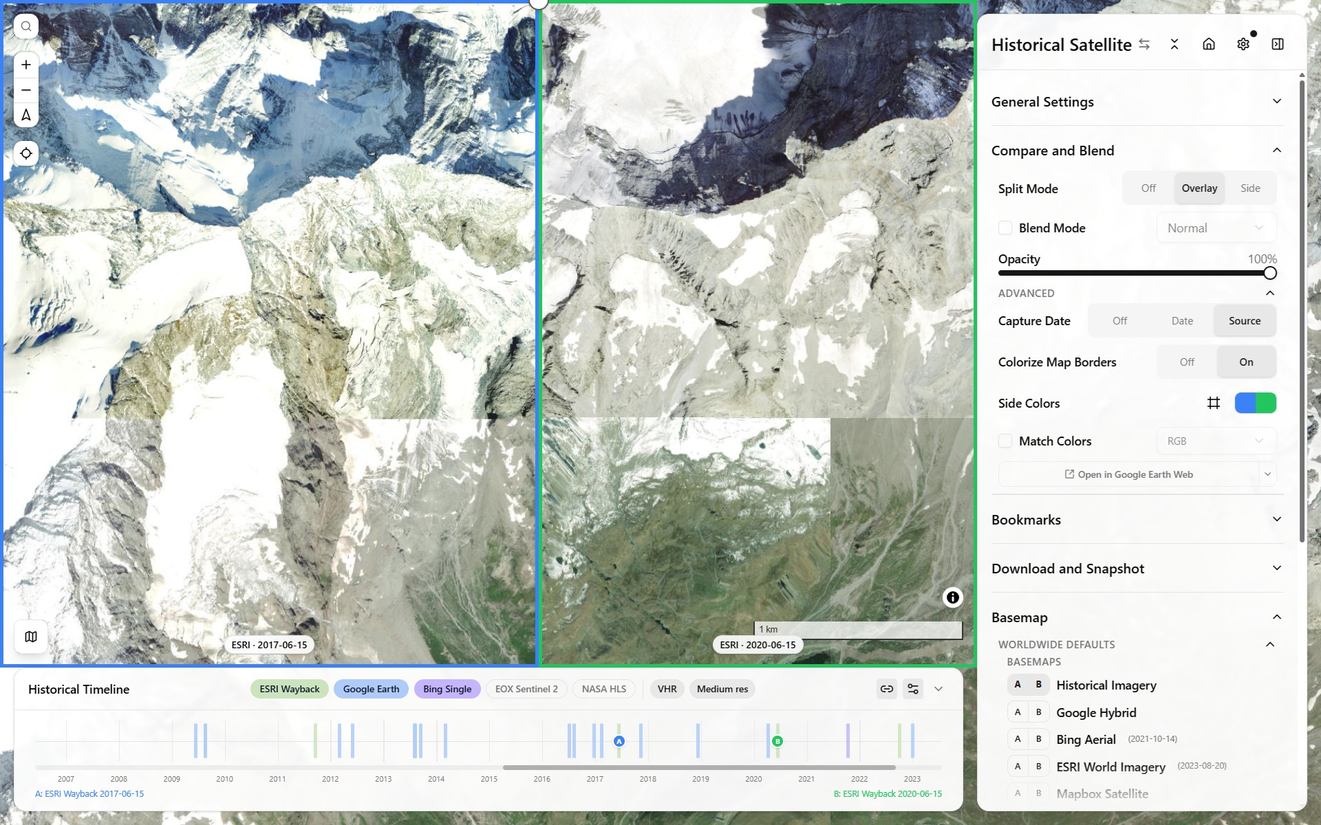
Historical timeline panel — scrubbing capture dates across providers
- Each active view gets a draggable handle on the timeline, positioned at its currently selected capture date.
- Source pills toggle which providers contribute ticks to the shared timeline. Every pill can be off (
timelineSources=none), leaving the catalogs alone on the track. - Resolution pills: unset means VHR only; the medium-resolution series (NASA HLS, Sentinel-2, Planet monthly, Landsat WELD) need Medium res on.
- Hovering a tick names it: the source and its date first ("ELI 2020", "OAM 2023-04-18"), then the item ("UrbIS-Ortho 2020"), then its catalog. The caption under a 2×1 split shows the item's name too.
- Zoom: mouse wheel zooms the timeline in/out around the cursor; a trackpad two-finger swipe pans. The zoom-out limit extends slightly (10% per side) past the oldest/newest real tick, so those extreme marks always have breathing room instead of sitting flush against the track's edge.
- Pan gutter: when zoomed in, a small gutter below the track shows where the current window sits within the full range — drag it, or click it, to jump.
- An off-screen handle shows a chevron; clicking it nudges the relevant edge of the view window out to reveal it.
The Catalogs picker
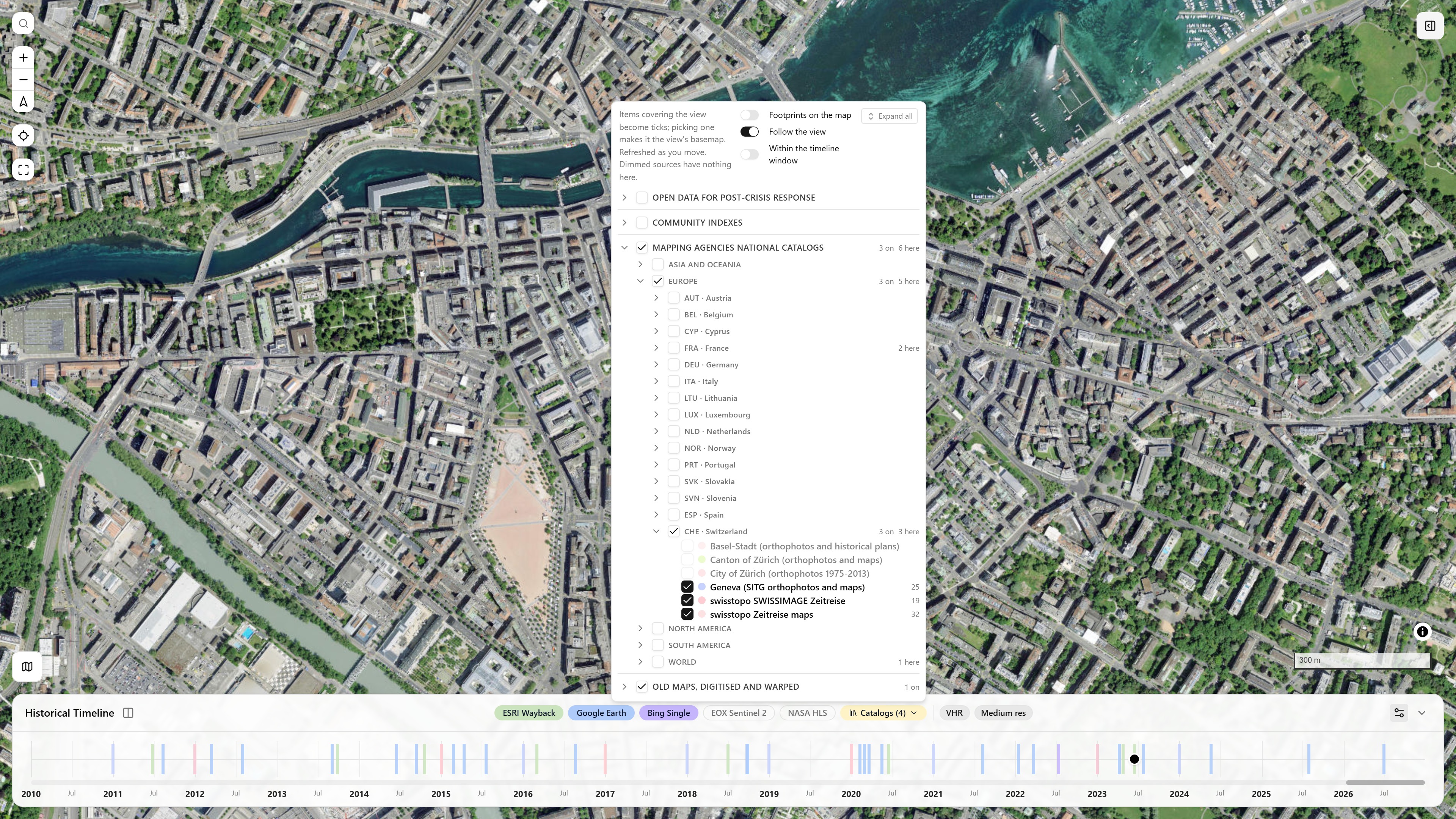
The Catalogs select (after the source pills) over Geneva: three Swiss catalogs on, with their item counts; the archives that do not cover the view are dimmed · open in app ↗
Catalogs is the button after the source pills (off by default). It opens a tree of imagery and old-map catalogs in four root groups:
- Open data for post-crisis response (OpenAerialMap first, then Maxar, Vantor, NOAA, Planet disaster data);
- Community indexes (the Editor Layer Index, NextGIS QMS, ArcGIS Online);
- Mapping agencies national catalogs (every archive under its continent, then its country with the ISO alpha-3 code, everything sorted by name);
- Old maps, digitised and warped (Allmaps and Rumsey first, then the dated catalogs: Allmaps' dated maps, the CORONA Atlas, Map Warper, Wikimaps Warper, SLUB Kartenforum, USGS topo maps).
What each catalog holds is on Historical Sources.
How to use it:
- Check a catalog (or a whole group). Every checked catalog is queried for the view as the camera settles, and its items become ticks in the catalog's colour. The selection is in the URL (
timelineCatalogs). - Each row shows its tick count, a spinner while loading, or "error". A group header shows how many of its sources are on and spins while they load. A group opens by itself when one of its sources covers the view; sources that do not cover it are dimmed.
- Every group starts folded; what you open is kept, here and in the Sources Coverage section (the same tree). The header has Fold all / Expand all.
- Two switches in the header: Footprints on the map draws every item found as a faint outline in its catalog's colour, and Within the timeline window asks the catalogs only for items dated inside the timeline's current zoomed window (STAC searches pass it to the server).
- Picking a tick makes that item the view's basemap (or drapes a warped IIIF map as an overlay), and the handle stays on it. Picking an item much smaller than the view and wholly inside it frames it on the map. Every item picked joins Your basemaps in the coverage tree, with its extent and a zoom-to-fit button.
- To find a map by name, anywhere rather than in the view, use Search by name in Sources Coverage: a dated hit lands on the timeline like a tick.
A tick's card
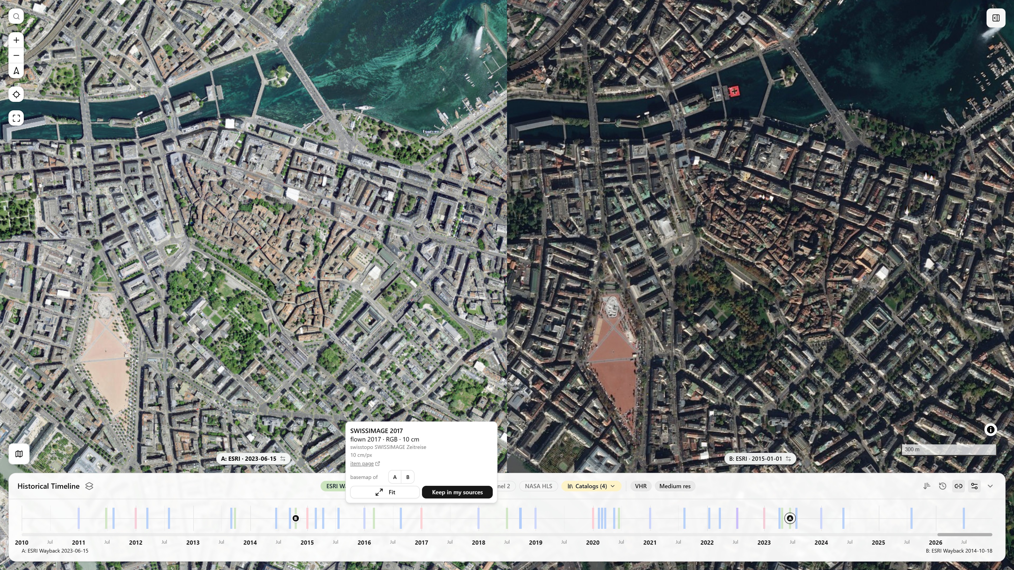
A tick's card in a 2×1 split: the item (SWISSIMAGE 2017, 10 cm), its catalog and page, basemap of A B to put it on either view, Fit and Keep in my sources · open in app ↗ (then hover a pink tick)
Hovering a catalog tick opens its card: the source and date, the item's name and catalog, its resolution and licence when the catalog states them (see what each catalog can tell), a thumbnail where one exists (OpenAerialMap, Maxar, Vantor, NOAA, Planet, SLUB) and a link to the item's page.
- The view grid puts the item on any visible view (as the view's basemap, or in its overlay stack for a warped IIIF map; a second press takes an overlay off).
- Fit frames its extent.
- Keep in my sources keeps it, and also puts it on the view when it is on none. A picked item is otherwise transient: shown on the map and the timeline, listed nowhere else (unless Picks join my sources is on in Sources Coverage).
- The ← and → keys step through every tick on the axis, whatever its source, starting from the one the view shows.
- A view keeps its item when the map moves somewhere the catalog no longer lists it.
Export
Export Historical GeoTiffs writes one RGB GeoTIFF per place, timeline provider and capture date in a date range, over the viewport or each drawn feature, bundled in a .zip: see Export Multi (Historical).
Dedicated historical-imagery entry point
The app's appMode (terrain | historical) controls whether the full sidebar or a stripped-down historical-imagery-only sidebar is shown — see the in-app Mode Picker (click the sidebar title). It's a shareable/bookmarkable URL param (?appMode=historical) like every other setting.
Visiting historical-satellite.iconem.com (and any subdomain of it) defaults straight into Historical mode on a first visit, with no query param needed — the main terrain-viewer.iconem.com deploy (or any other/unknown domain, a fork, localhost, a preview URL) keeps the normal Terrain default. Once you've explicitly switched modes in your browser on a given domain, that choice is remembered for next time.